Monthly Archives: August 2016

Suez Canal

One of our reasons for returning by sea was the itinerary of the Cunard liner, Queen Elizabeth, which included calls at Istanbul, Athens, and Malta, all of  which Denise had visited as a teenager and wanted to revisit. (Cunard was also offering a really good rate so we had made arrangements with Cunard to join the Queen Elizabeth at Aqaba.)

After living in Panamá, we were really looking forward to a transit of the the Suez Canal. We started our transit early in the morning, following the Europa II (which we had seen in Aqaba) and the Queen Mary 2, which we would join in Southhampton.

Suez-11

Line ahead through the Canal. Note the tugs close by in the event that the side winds cause problems. (The winds can be so strong that the ships actually “crab” just like airplanes.)

As ships cannot pass in much of the Canal, ships are grouped in convoys and timed to pass in the lakes or the new double section of the Canal. In the early days, ships tied up to piers on the banks in order to pass. We had 24 ships in our convoy, beginning with three liners of which we were the third. The entire length of the transit we were greeted with cheers, whistles, and a cacophony of horns. Three liners in a row, two of the from Cunard, was quite a spectacle and the folks loved it.

Suez-2

Container ships falling in line to follow us through the Canal.

There was plenty to see. Various monuments, security outposts, ferries crossing the canal and lots of towns, all with trees and green plants in contrast to the desert elsewhere.

At one point ships were travelling south on a different channel and their stacks and containers could be seen through the sand dunes. Quite an interesting sight as there was no water to be seen!

Suez-15

Ferry. Notice the container ship going south in the other channel. Zoom in to see all of the people on the ferry cheering and whistling. 

In addition to  opening the second lane, there is constant maintenance all along the Canal. The sheer amount of sand is impressive. Not the mountains of Panamá, perhaps, but still a lot of work.

Suez-12

The lakes were full of ships.

Suez-7

Never one to miss a photo opportunity, we maneuvered with the Queen Mary 2 after we left the Canal.


After the transit, we headed for the Dardanelles and Istanbul.

Suez-8


Heading for the desert

After leaving Petra, we headed for Wadi Rum, a desert area with spectacular scenery made famous by Lawrence of Arabia, the man and the movie, and by filming for various other films including the recent “The Martian”. Fred was skeptical – “We’ve done the Sahara, the Kalahari, and even the Great American Desert. Why do you want to go to the Valley of the Moon?” Denise held firm and we had wonderful time! (http://wadirum.jo)

Everyone goes to Wadi Rum to see the desert. But, in fact, the Bedu have stayed at Wadi Rum over the years because there is so much water. You won’t see it immediately, but once your eye gets trained, the signs of water are everywhere.

Wadi Rum-15

Water Trap

We stayed in a luxury Bedouin camp (or tented hotel) novel and quite comfortable. We arrived rather early and found the place deserted. Probably should have made a stop en route but we were a little short on information at that point. A little more Arabic would have been useful at times!

Wadi Rum-5

View of the Dining Area

However, once we sorted out what was happening, we crashed a party of Italian tourists and enjoyed a great buffet lunch of salads with chicken and rice. The meal was cooked traditionally – buried in the sand with a wood fire on top.  This, of course, made for great photo ops. The meal was further enhanced by a dancing waiter! We then relaxed for the early part of the afternoon in the shaded divan with the desert coolers running.

As the temperature began to cool, our driver arrived to take us on a tour of the desert. We made ourselves comfortable in the back of the pickup truck and headed out to our first stop; the site of the filming for the “base camp” in the movie “The Martian”. Our guide had been present at some of the filming so was very enthusiastic about it all.

Wadi Rum-9

Site of Matt Damon’s base camp

We also saw several sites relating to Lawrence of Arabia (the person, not the movie) along with scenic sites like a natural rock bridge.

Our guide stopped just before sundown and made us tea in the desert before our return to the camp just after sunset.

Wadi Rum-16

Tea on the Sands

Wadi Rum-17

Sunset

Dinner was a traditional meal called sarb, cooked in a fire pit in the ground. We were served an excellent chicken and mutton with assorted vegetables and pilafs. The temperature was starting to drop so we headed back to our tent for the night.


After an excellent Arab style breakfast with hard boiled eggs, bread, foule and toppings, we headed out. We made a stop along the way at the historic train station of the Hejaz Railway where  old carriages and a locomotive could be seen. The Hejaz Railway was an engineering marvel. It was a tragedy that it was never really rebuilt following the First World War. And, in today’s political climate, it probably never will be. (https://en.wikipedia.org/wiki/Hejaz_Railway)

A modern train still runs, carrying potash, we saw it several times as the camp is close to the main line.

And on to Aqaba where we hope the Queen Elizabeth awaits us! Our driver had arranged access to the port and he left us right beside the ship. Other than the fact that we were trying to go up the gangway while thousands of passengers were coming down, it was the easiest ship boarding we have ever had. We were greeted by the Purser’s office and escorted on board to our cabin. We had hoped to visit Aqaba a little before boarding but we seized the moment and a nearly empty ship to do laundry and settle in.

Wadi Rum-23

As we waited to sail, we watched the Europa II depart.

Petra from on High

Our second full day at Petra was one of the highlights of the trip. Fred had been impressed by several  photos taken of the Treasury from above and he had heard rumors that there was actually an easy route to get to the vantage point. The challenge was to find a guide who knew the way. A visit to the guide office found Achmed, who would guide us. He recommended taking horses to make the climb easier for Denise and although Fred was very unsure about this, we agreed. It proved to be a wise and most enjoyable choice. Achmed discussed horses just inside the gate and procured three excellent ones, complete with their owners, and we set off. The horses ambled at an easy walk, except for when the track was too dangerous for them to carry anyone and then we dismounted and walked beside them.

At this point we pause for a quick aside. Tourists today enter Petra through the narrow and spectacular Siq, but the site is, of course more easily accessible from the north and south as the city actually sits in a broad valley. And, of course, any invading army could easily climb over the mountains. So why is Petra where it is? Water. The mountains around Petra actually get a fair amount of rain and the Nabateans were experts at channelling that water into the city where it was stored in cisterns. And, while it is not immediately obvious from the tourist route, Petra is surrounded by large, flat plateaus which are perfect for agriculture.

It was quite fascinating to be up above the Petra Valley on the flat agricultural lands. The Crusaders destroyed the olive groves and they have never been replanted.

Petra2-13

A project is currently attempting to recreate and reestablish the Nabatean water control methods with a view to irrigating for agricultural purposes. The Nabateans grew grapes and olives and traded wine and olive oil from the Petra valley.

Petra2-12

We had quite a scramble to get to the viewpoint above the Treasury but it was worth it.


The first view was spectacular. (Like all of the images, this one is quite large, click and zoom.)

Petra2-15

And then, when you climb down, you come to this: Notice the people on the left, they have come up one of the steeper climbs. If you zoom in and look directly in front of the facade, you can see the underground rooms that have been unearthed.

Petra2-19

Denise paused to take in the view.

Petra2-17

And what can she see? Zoom in on the next picture and see if you can guess. Hint: Look for something man made. (Answer at the bottom of this post.)

Petra2-16


Back on the horses and off to the Place of High Sacrifice. After more riding, walking, and scrambling, we came upon the site from behind. The Nabateans weren’t adverse to digging and carving – notice that the two pylons are carved out of the mountain, not erected. Can you imagine the work it took to smooth the cliff faces on the right of the image?

Petra2-27

Back in the day, it looked like this.

High Place

The High Place of Sacrifice.

The point of a high place is to build an altar and the Nabateans did some beautiful stone work with channels to carry liquid. We can simply imagine what liquid. From the stone work still remaining, it is likely that much of the site had walls at one time.

We wandered and took photos before beginning the descent of the steps. It was certainly an easier descent than it would have been to climb up. Fred was never able to find the section of stairs that had scared him so as a child.


Back in the valley, we admired the theatre. By this time, after Amman, Um Qais, and Jerash, we were about theatered out!

Petra2-33

We made our way back to the Treasury to hit the refreshment stands and to indulge in a bit of people watching.

Achmed composed and took a great shot of the Treasury in Fred’s glasses.

Petra2-37

Fred took one last stab at a slightly different take on the classic Treasury-through-the-Siq shot.

Petra2-41

Goddess through the Siq.

We hiked, OK, trudged, our way back up through the Siq, stopping to admire what had been a fabulous carving of a camel caravan. Complete with a person leading. Sadly, the soft sandstone has washed away, but you can see that the water course actually ran behind the camels’ legs.

We were back to our hotel by about 4.00 pm. Again after a shower and a rest, we headed to the buffet for dinner. Afterwards, we stopped to chat to a gentleman putting sand in bottles in various patterns and designs. Fred remembered these from his childhood and he was happy to purchase a couple. Sadly, he had closed up by the time Fred went back for his camera.

And what could Denise see? The top of the Monastery. Amazing! Actually, if you know where to look, you can see it from several of the higher points around Petra.

And on to Petra (Part One)

Why does one go to Petra? Simply put, it is one of the more unique historic sites on earth and near the top of anyone’s bucket list. The Wikipedia has lots of background: https://en.wikipedia.org/wiki/Petra

In Fred’s case, it was another chance to go home. Back in the day, the road looked like this:

The Road to Petra

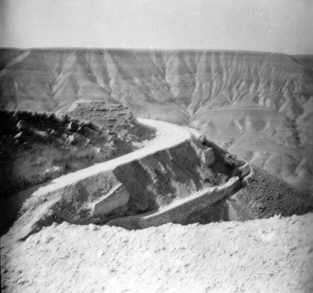
The old highway to Petra.

This translates to a lot of grinding in low range! 4×4 geeks may be interested to know that the trip was made with a Land Rover and a Jeep Station Wagon. Today there are excellent paved roads, complete with travel centers.

We had booked a room at the Movenpick Hotel, which is right at the gate to the Petra ruins, which proved to be an excellent idea. The hotel was lovely and we checked in thinking that we had picked well.

Movenpick Lobby

Beautiful lamp in the hotel lobby.

As a point of reference, back in the ’50’s one stayed in the ruins themselves, either in caves or tents.

Fred

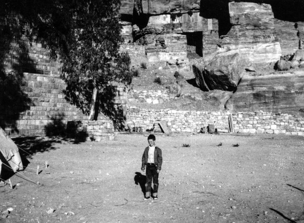
Fred at Petra in 1957 or 58. Visitors stayed in tents (on left) or in the caves at the back of the picture.

The accommodations were a bit more Spartan, but as we discovered, you were a LOT closer to what you wanted to see.

We then went off to look for soap powder and drinking water as hotels provide a small bottle per person in each room but it was hot and dry and we were in need of water to both drink and carry with us on our adventures. We had success and returned to our room to wash some of our dirty clothes and hang them on the line over the bathtub to dry. Then we wandered over to the main ticket office for the Petra ruins for a general reconnaissance as we had been told it was necessary to show a passport and we wanted to check this. We had considered signing up for a “Petra by Night” visit but had not been sure. However, we discovered that we had only one chance to see Petra at night and that was the same evening. So we signed up quickly and headed back to the hotel for an early dinner at the evening buffet. This proved to be amazingly good, especially the excellent Jordanian dish that we both enjoyed. They even had lots of vegetables!

The Treasury by Night

We were back in the courtyard by 7.30 pm to head off towards our first glimpse of Petra. And what a glimpse! The Treasury is a 40 minute walk from the entrance, through a more open section and then through the famous Siq, a 1.2 Km canyon and the way was lit by candles which gave a romantic atmosphere but made it hard to see the way over the rough stones.

Petra1-5

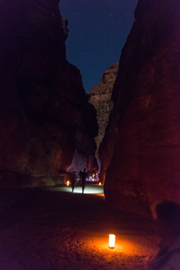
The Siq by starlight.

But we made it in one piece, ankles intact, and we took our place on the mats and watched the different color lights playing on the front of the Treasury.

Petra1-6

Treasury by moon and candle light.

One local performer played a flute and another played a rehbab. A bit touristic, perhaps, but both were very evocative. At the end of the performance, we walked back to our hotel.

Into the City

We decided that our goal for the first full day at Petra was the Monastery (El Deir), a fairly steep climb. So, we bought our tickets at about 8.30 am and headed off to the ruins. The first part was an easy stroll down the hill from the down of Wadi Musa (Valley of Moses), where the hotels are located, to the city of Petra itself.

A quick map reference:

Karta_Petra

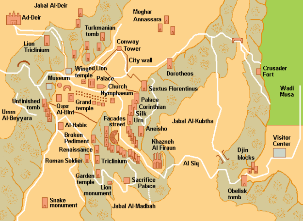
All of our rambles start at our hotel, next to the visitor center on the right of the map and then continue down through the Siq. The map is not to scale, but as you can see, it is a (long) hike to get anywhere! This leads to a thriving business of carriage, donkey, horse, and camel rides.

Petra1-55

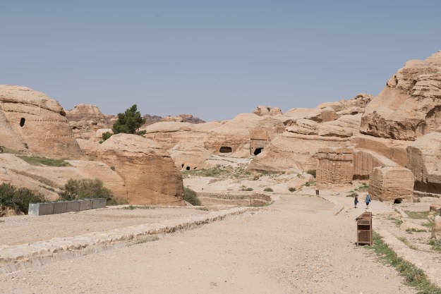
It was interesting to see the early part of the walk, which had been invisible the night before, and where there were three  monuments known as the Djinn (A djinn is a spirit, the origin of the word “genie.”) blocks as well as the Obelisk tomb.

Petra1-56

We then came to the mouth of the Siq. There had been an arch here.

Gateway Arch

The arch has since collapsed.

But now little remained.

We continued on through the Siq and Denise takes credit for our best version of the obligatory classic shot:

Petra1-9

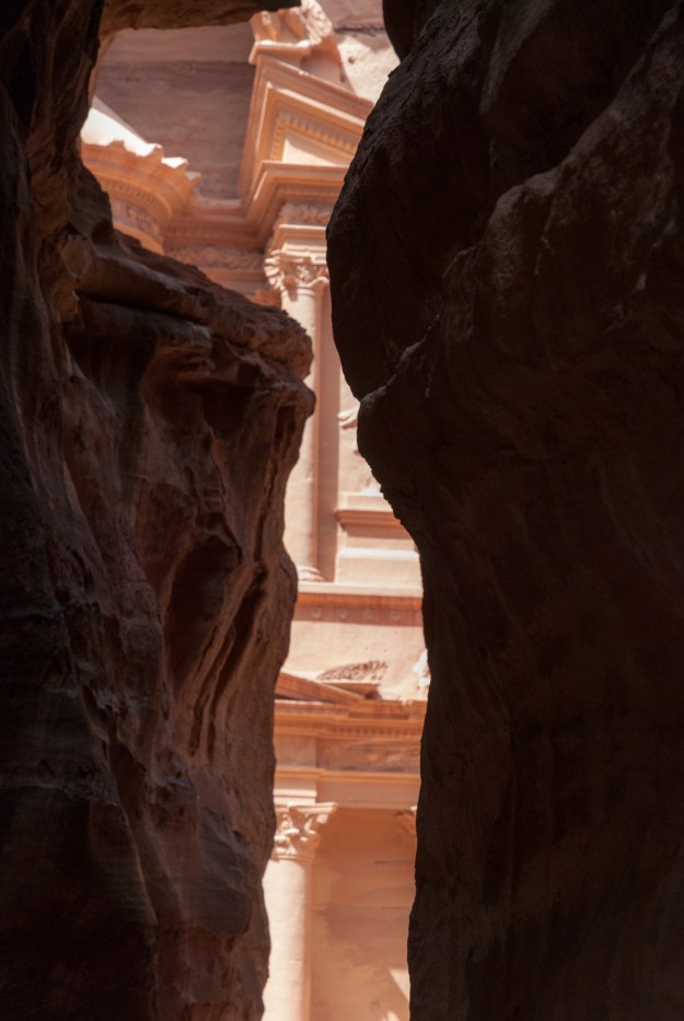
The Treasury through the Siq. A classic shot.

Fred was fascinated by the changes that had occurred since he had last visited.

Petra1-11

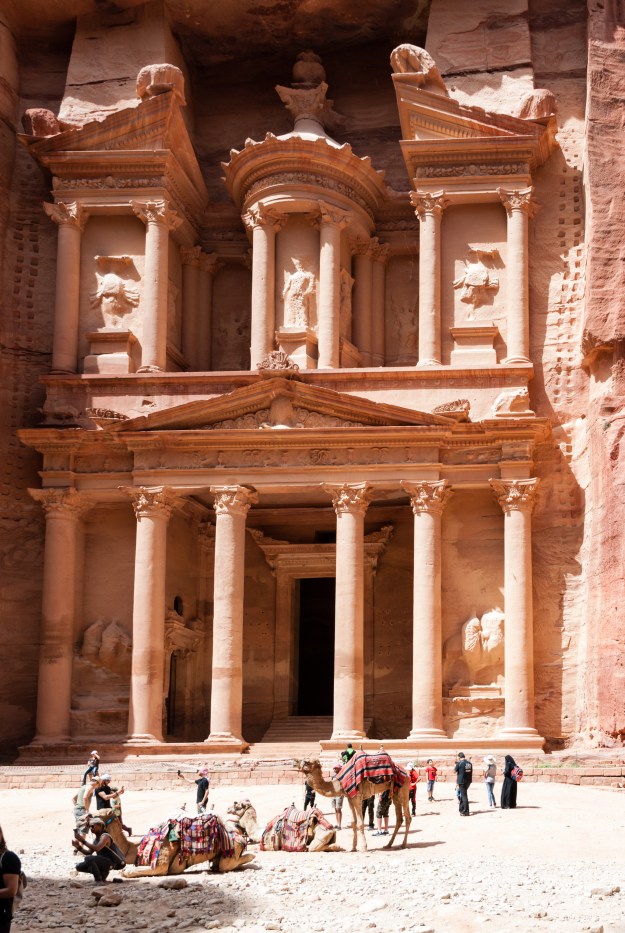
Tourists at the Treasury.

Perhaps the greatest changes are that:

— One of the columns (third on the left) has been restored, and,

— The space in front of the Treasury has been excavated.

In the old days, even up until the 1950’s, the ground was much higher and most of the outer parts of the Treasury were deep underground

The Treasury

The broken column is clearly shown. Note the river and the level of the ground. At least twenty feet of dirt and spoil has been excavated and they have found rooms in front of the facade.

Two views of the center of the facade. My camera gear and skills have improved a bit over the years.

Many complain of the crowds, but, in reality, the people watching was fun. And the steady flow of tourists certainly helps the local economy.


We then made our way down the main street or Street of Facades towards the steps for the Monastery.

Petra1-20

Ancient garage.

Denise decided to take a donkey part of the way, though Fred climbed the entire distance. Denise was impressed.
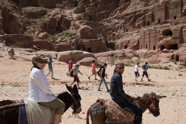
Petra1-18

Donkey Riding.

Fred

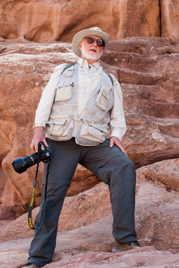
Fred, just as tired as he looks!

The climb is long, but offers amazing views back down the valley.

Looking Down

The main city center is down there on the valley floor with a wall of tombs in the background.


Towards the top we stopped for a lemon with mint from a really pleasant vendor with a lovely shady divan where we could rest for a while. It was very hot and sunny and we carried two bottles of water but were consuming them fast. And then, we turned the corner.
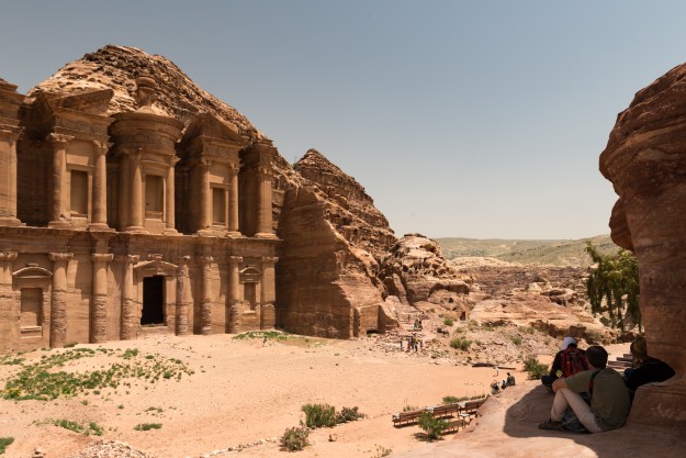
The Monastery

First View

Your first view of the Monastery as the trail comes around the corner.

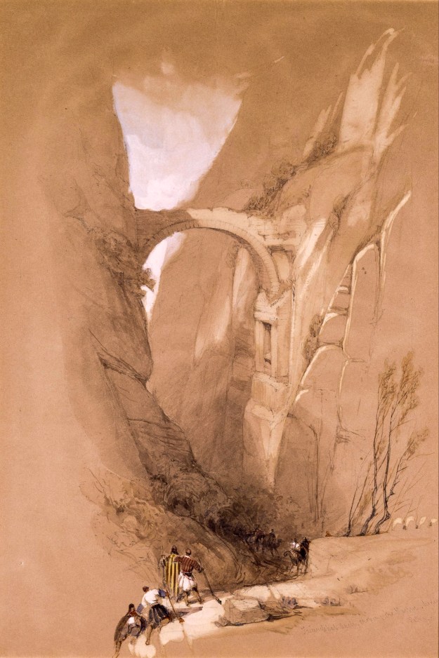
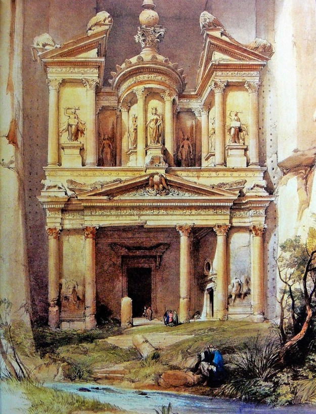
The Monastery has long been one of the classics of Petra. The painting is by David Roberts: https://en.wikipedia.org/wiki/David_Roberts_(painter)

The Monastery

The "Classic" View

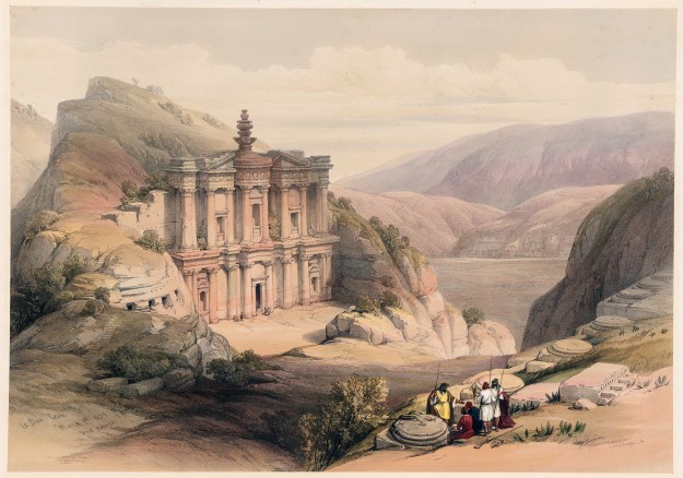
Comparing the two images, the  realism and accuracy of some of these old images is simply amazing. As always, expand the images for more detail.

We paused for photos and to admire the wildlife.

Once at the top, Fred climbed even higher to a lookout where a man was playing an oud.

Oud Player.


View from the Top of the World.

This view would inspire anyone to practice their scales!

Denise remained gazing at the Monastery frontage and ate an apple, which was to be lunch for the day.

Denise and Friend

We started back down and again stopped at our friendly vendor for a very gooey Kit Kat and more mint lemon drink . Then we started the descent, step after step after step (more than 800) and the descent alone took almost an hour.

Trail to the Monastery

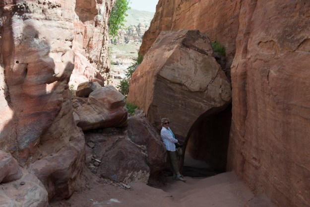
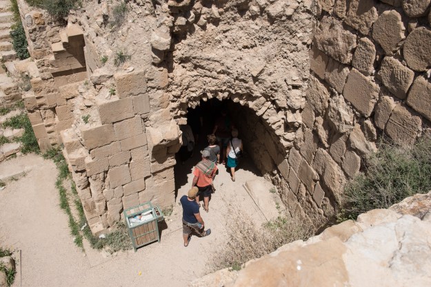
Fallen rock tunnel on the trail to the Monastery.

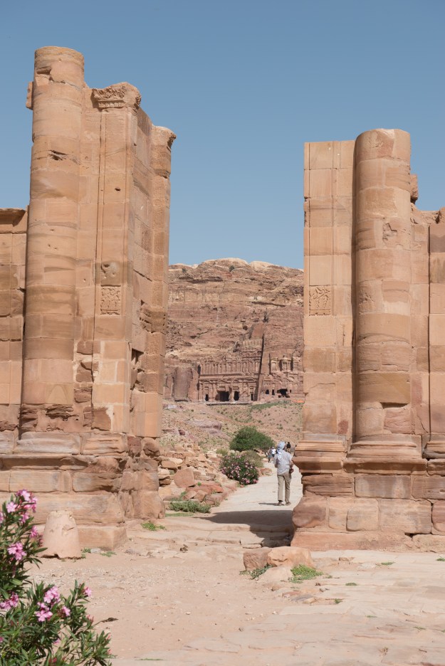
We then visited the Grand Temple. This temple is actually larger than the Temple of Artemis at Jerash, but at Petra, most of the attention is focussed on the rock carved structures. It is easy to forget, that back in the day, the free standing structures were even larger. Sadly, most were damaged or destroyed by an earthquake.

Petra1-38

Petra1-39

We continued down the Street of Facades in front of the tombs and found a vendor with shade and ice-cream. So we stopped for a mint and lemon drink and an ice-cream (you may be noting a pattern here!).
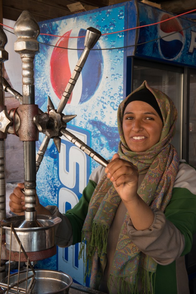
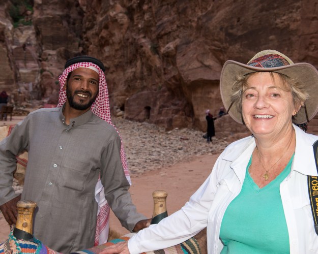
Orange Press

Fresh Orange Juice.

We were tired and decided to return to the Treasury on camelback. It was a short ride, about 10 minutes, but it was something that Denise had wanted to do. However, Denise is delighted to say that having done it, she will not do it again as her back did not enjoy it as much as she did! Fred enjoyed it and was only sorry the ride was so short.

Denise and Camel Driver

Denise finishing her camel ride. (Beats walking at the end of a long day.)

Camel Ride

Heading into the lower Siq.

Then it was time for the hike back to the hotel. We made it back to the hotel by 6.00 pm, showered and staggered down to the buffet again. The Jordanian dish was different on this evening, but still excellent, and we were too tired to even walk to an outside restaurant. We were exceedingly glad that we had picked the Movenpick Hotel right at the gate to the ruins; ten hours, and 800 steps up,  is a long day!


Kerak Castle

Off again after breakfast, which proved much better than dinner, we headed to Karak Castle, best known as the castle of the crusader Reynald de Châtillon. The scenery on the old “King’s Highway” was spectacular.

Road to Kerak

The dam is new.

Raynald de Châtillon is a controversial fellow, often vilified in popular history, most recently in the movie “Kingdom of Heaven.” The truth is most likely that he was simply a man of his times whose morals and values were different from ours. He started off as a second son, and thus could not inherit, so he became a mercenary and then spent fifteen years as a prisoner of the Muslims before being ransomed. All of that would be enough to influence anyone. He is famous for his raids into Egypt and Arabia, earning Saladin’s personal enmity. (It appears that he was, however, innocent of the murder of Saladin’s sister.) You can read more here: https://en.wikipedia.org/wiki/Raynald_of_Châtillon

This may be the place to put in some links on the Crusades. Beyond reading the famous “The Crusades” by Harold Lamb, there is a simply amazing site here: https://europeanhistory.boisestate.edu/crusades/ The really hard core can take a full on line course on the Crusades. And given world events, it would be most useful if some of our commentators would do just that. The book, “The Crusades” appears to be out of print, but you can read it here: https://archive.org/details/cruasadestheflam006191mbp (I bought my copy used and discovered that it had belonged to Ambassador Parker Hart (https://en.wikipedia.org/wiki/Parker_T._Hart) who was purged by Secretary of State Henry Kissinger. I feel like I am holding a bit of history each time I read it.)

For the rest of us, on July 15, 1099, the Crusaders took Jerusalem after a brief siege. They then proceeded to slaughter almost all of the Jews and Muslims who lived there. It appears that, contrary to some reports, the Christian inhabitants had already been expelled form the city. (https://en.wikipedia.org/wiki/Siege_of_Jerusalem_(1099)) The differences between “eastern” and “western” Christians were already so pronounced that the Crusaders had no compunctions about killing of eastern Christians. The Crusaders then set up the various kingdoms of the Outremer and, to defend them, started building a chain of large castles, running from Krak des Chevaliers in Syria to Montreal in southern Jordan. Kerak was an important part to this chain. (Which led, of course, the the construction of counter castles like Ajloun, visited in this post: https://diplostrat.org/2016/07/27/heading-north-the-adventure-begins/ )

Kerak has been fortified since Biblical times but the castle that you can visit today was started in the 1140’s. It took about twenty years to build the first castle and the castle was used by the Crusaders, the Umayyads and was still in use in Ottoman times. This has lead to many changes over the year, but the essential character of the castle remains. It is a “spur” castle, flanked by several enormous glacis and accessible only on the north side. The north wall is huge, more like a Keep than a wall or gate house and proceed by a deep fosse or moat. It is easy to see why the castle was able to withstand several sieges. The castle was interesting in that it was built on a cliff but was also built down into the cliff. Between tunneling in the mountain and filling in the space between the walls, Kerak sometimes feels more like one big, multistory building, than a classic wall-around-the-inner-ward of other castles. However you describe it, Kerak is is one of the big ten of castles in the world.

Kerak Castle.

Turning on the way-back machine, Kerak was one of Fred’s favorite destinations as a child.

Kerak

Kerak from the Lower Court

Kerak today is a well preserved archeological site. Back in the 1950’s it was a wonderful playground for kids. especially those obsessed with history. And cows. Kerak today has more visitors in a day than it would have had in a month. Photos were taken by Fred or, more likely as they are full frame, by his Father. (Fred had a half frame camera as a child.) From their size, they may have all been contact prints.

Cow taking in the sights.

Cow taking in the sights.

Part of Kerak’s strategic importance came from its location astride the Moab trade routes. From its heights you can see all the way to the Dead Sea.

Kerak-34

We found ourselves acquired by a charming and authentic sounding guide, which given a total lack of any form of explanation (unlike Aljoun Castle which had been well documented), made our visit much more understandable. We would have been guessing at rooms otherwise. That said, all guides must be taken with at least some salt.

Guide

71karakplanbig

1: Present entrance
2: Original entrance
3: North and south moats
4: Cistern
5: Glacis
6: Chapel
7: Mameluke residence
8: Museum

As you can see from the map, there was a lot to see. Worth noting that the castle was originally surrounded by Kerak town, of which little remains. The town was sometimes taken and destroyed when the castle still held out. The modern Kerak remains a largely Christian community.

We started at the north face. Over the centuries, the fosse has largely been filled in. There would have been wooden bridges over the fosse to the main and postern gates; wooden so that they could be easily destroyed when the castle was attacked.

North Wall

The little opening on the left was the Postern gate. You would first have to cross the fosse or moat, exposed to attack from the battlements and arrow loops. And, when you got there, there was no place to mount a ram.

Once inside, we could look back at the massive North Wall. While most of the construction is of stone, there would have been lots wooden and mud brick walls and floors as well.

North Wall

From the Upper Court. Note the two huge galleries. The main gate was somewhere to the left in the image.

The great North Wall was a warren of passages and rooms.

Ahead of us was the inner ward, divided into Upper and Lower Courts.

Looking South

Upper and Lower Courts.

It has changed a bit over the years.

Looking South

Shows the southern keep and the upper and lower courts.

We started out underground. In Kerak, more than any other castle we have visited, the underground galleries are simply amazing.

Denise and Guide

We saw the multiple levels of cells (some with fireplaces for the better class of prisoner!) and huge stables.


We had a special guide who knew all about the underground passages.


There are great views over the modern town as well. Don’t know the date of the glacis, but imagine trying to fight your way up that slope.

Looking North

View of towers, the glacis, and the modern town to the north.

As noted, many of the “surface” ruins are still a long way underground.

Looking Down in the Upper Court

Tourists entering the Church.

There is a lot more excavation to do. Maybe there will be more to see if we make it back again! Kerak belongs on every history nut’s bucket list.


The Dead Sea and Madaba

Fred remembers staying at the Dead Sea Hotel as a child. It was right at the mouth of the River Jordan, just a few miles from the main Amman to Jerusalem road. The hotel is long gone now, but it was quite lovely.

The Dead Sea Hotel

Taken about 1957.

The Dead Sea is famous, of course, as the lowest point of dry land on earth, at about 1300 feet below sea level. The used to be a sign on the road to Jerusalem to let you know when you had climbed back up to sea level. Like the Great Salt Lake in the United States, it is very salty, so salty that it is almost impossible to swim underwater.

Sea Level Sign

Sign on the road from Jericho to Jerusalem

We checked into our hotel and decided that we must do the needful and swim in the Dead Sea. So we changed into swim garb and headed out. With the loss of the West Bank to Israel, all of the hotels are in a huge tourist complex on the east bank of the sad and a hit higher up the slopes. The level of the sea has dropped so much that it is actually quite hard to get to the water. We walked for about 20 minutes down to the “beach” which turned out to be rocky and very hard to walk on. But we made it into the water, flopped around a bit, and then emerged. “Been there, done that”!! It is indeed salty, so salty that you cannot sink and it really stings if it gets onto your face! We rinsed off, walked our 20 minutes back to the hotel and Denise enjoyed a swim in the lovely warm pool. Grumbling that “it wasn’t like that in the old days!” Fred went off to enjoy a massage in the spa.

The Marriot Resort at the Dead Sea.

The Marriot Resort at the Dead Sea.

We watched the sun set over the West Bank and the lights of Jerusalem start to show on the ridgeline and headed for dinner. Fred was amazed, Jerusalem simply wasn’t that large back in the day.

Dead Sea-2

Sunset over the West Bank.

We then went to watch the belly dancer perform while we enjoyed Turkish coffee and even stayed for her second show before calling it a night! Fred’s mother could never watch scenes of “belly dancing” in Hollywood films. She was an enthusiastic ballroom dancer and one night, in Beirut, she and a friend, also an excellent dancer were watching a dance performance. When the set ended, the friend asked the dancer to show her some of the moves. The dancer laughed and said, “Oh Madame, for you it is too late; I stared learning when I was five years old.” So although Rita Hayworth and others are indeed lovely,  their Salome initiations look very awkward when you have seen the real thing. It was pleasantly warm and it was fun to people watch. Everyone from tourists in shorts to ladies in abayats – Jordan is a wonderful country.


On to Madaba via the Baptismal Site

 Off again the next morning, we made a last minute decision to go to the Jordan River Baptismal Site, a visit that proved fascinating and far more interesting than Fred had anticipated. Fred was in curmudgeon mode, grumbling that he had already been to the river on a picnic and one of his friends had “baptized” himself by falling in. (His mother had not been pleased.) We drove to a central ticket office/car park where we waited for a bus and guide. The Jordan River is the border between Jordan and Israel and security is very tight and thus the various sites can only be visited in a group.

The first thing that we learned is that many of the sites were re-identified and excavated only after Fred left Jordan in 1960, so, with the prospect of “new” ruins, Fred got all interested. Like all things Biblical, there is controversy about the Baptism. The Gospel of John says that it took place in “Bethany beyond Jordan.” The River Jordan has, of course, moved many times over the years. It is also worth considering that while may people today ascribe special qualities to the River Jordan, to John the Baptist, it would have simply been another, albeit larger, river. Thus there is considerable reason to believe that he would have actually performed the Baptism in the clear waters of the spring at Bethany, rather in the muddy river – what is the point of a spiritual cleansing in dirty water. Whatever the truth, by third century the early Christians accepted Bethany as the site and built many churches there. (The site is on the Madaba Map.) These churches were destroyed or fell into disuse with the Muslim conquest and are only now being unearthed. There is an excellent site on the subject and if you drill down, there are detailed accounts of the history of the site. You must remember, however, that this is a Jordanian government site and there is intense “competition” from the Israelis to attract Christian, especially American, tourists. Read on: http://www.baptismsite.com

After a short wait, our bus arrived and off we went, passing first by the site of Elijah’s ascension, before other sites connected to John the Baptist. As noted on the site linked above, you could spend a long time visiting all the sites in the local area, many of which provide an interesting insight into the nature of early Christians. The Jordan River is much reduced in size since the 1950’s in part due to water being removed from it by Israel. (Israel’s “miracle in the desert” comes with a price, much like our depletion of western aquifers.) The river has always been  muddy and most historians have established by reading travelers’ accounts and through archeological digs that the true baptismal site is probably about 60 meters from the present river, at the site of a spring which used to drain into the river. There are ruins of the various churches which were built over the spring at different times and it is very possible that this clean spring water was used for baptisms, rather than the always muddy Jordan.

This link describes the rediscovery and the purpose of the foundations in the photo:http://www.baptismsite.com/archeological-findings/

Dead Sea-10

Ruins of Byzantine Church constructed over the spring where it is believed that John baptized Jesus. The large objects are the foundation pillars. As was the Byzantine custom, the church often completely enclosed the site.


Dead Sea-11

Church built upon Church built upon Church

Dead Sea-15

Modern Church at the Baptismal site

The Jordan River site on the Israel side has been highly developed for tourists and we watched various visitors immersing themselves in the muddy and unsavory looking water.

Dead Sea-12Dead Sea-13


We then headed out to Mt. Nebo, where there is an old church called the Moses Shrine, which is reputedly where Moses saw the Promised Land before he died. The church was unfortunately closed but we did see an old mosaic from the church and, of course, a huge selection of schoolgirls! As a historical note, it is worth noting that one cannot see the land “flowing with milk and honey” from Mount Nebo, only the parched Jordan Valley. There has long been agriculture around Jericho, but the rest of the landscape, as you can see, is rather bleak. The fertile lands lie far beyond, between the Mediterranean and the hills were Jerusalem is located. It is possible that Moses stopped here because the people of Jericho blocked passage. Whatever the truth, Mount Nebo has long been a site of pilgrimage, traditionally along the old Roman road from Jerusalem.

Dead Sea-16

Dead Sea-18

Beautiful inscribed column, dedicated to Caesar Antonnius Pius. (Scholars debate his success against the Parthians and the Britons.)

More about Caesar Antonnius: https://en.wikipedia.org/wiki/Antoninus_Pius

On to Madaba, where we stopped first at St. George’s Church to see the famous mosaic map of the Holy Land, crafted in AD 560, it is the oldest map of the region and gives many insights into the region, including, as noted, the location of the Baptismal site. Jerusalem is shown, as is the Dead Sea with the fishes swimming away from the salt. There is also a small museum at the Visitor Center which we enjoyed.

Jerusalem

Close up of the medieval city of Jerusalem, showing the Cardo down the middle and the Church of the Holy Sepulcher in the foreground.

After a quick lunch, we headed to our hotel which proved to be in a residential neighborhood and quite nice. We took a much needed nap and then headed down to the pool for coffee and a nice chat with the Hotel Manager as the sun set. Dinner was somewhat of a disappointment but we had not noticed any obvious restaurants in walking distance, so decided to stay put. We should have been more adventuresome!


Jerash, Our exploration of the Decapolis Continues

And finally on to another Decapolis city, Jerash. (https://en.wikipedia.org/wiki/Jerash) It can be argued that if you can only visit one Roman site in your lifetime, it should be Jerash. As the city was rarely attacked (most of its life it did not even have walls) and because it was abandoned after an earthquake, there are few other sites in the world where the original layout of a Roman city, with its Cardo and crossing streets is so easy to see. Fred remembers picnics at Jerash as being particularly wonderful.

We arrived in the evening and checked into our hotel. (https://www.tripadvisor.com/Hotel_Review-g293988-d1212305-Reviews-Hadrian_s_Gate_Hotel-Jerash_Jerash_Governorate.html)

The Hadrian's Gate hotel, literally across the street from the entrance to the ruins.

The Hadrian’s Gate hotel, literally across the street from the entrance to the ruins.

Fred took a quick photographic tour of the street before we stepped out for Jordanian fast food for dinner.

First, a review of the ten cities of the Decapolis:

The Decapolis

We started our visit to Jordan in Philadelphia (Amman) and then went to Gadara (Um Qais) and now we are at Gerasa (Jerash). We were up and about early and into the ruins via Hadrian’s Gate by 8.30 AM.

It was delightfully cool and there were no schoolchildren! The ruins are extensive and much has not been excavated. So get your sunhat, water bottle and come along. The ruins look a bit like this:

Map of the Ruins

We entered at Hadrian’s Gate on the left of the map. Note that the arch was well outside of the walls, which were not, in fact, built until late in the life of the city. Our guidebook had warned that a visit needed 3 to 4 hours to do it justice and indeed, we spent about 4 hours there and saw most of it, including the sheep and goats grazing amongst the ruins. We saw the hippodrome (and imagined the chariot races), the Forum, the Agora, the Cardo Maximus or colonnaded main thoroughfare, temples to Zeus and Artemis, the Nymphaeum (public water fountain), multiple theaters and several churches (dating from the Christian times, often using stones from the aforementioned temples in their construction). Each crossroad had its tetrapylon (archway with four entrances) which solved the problem of roads not quite lining up!


The South Theatre is stunning.

South Theatre, looking towards the Temple of Artemis. Forum to the right with the modern city behind.

South Theatre, looking towards the Temple of Artemis. Forum to the right with the modern city behind.

Perhaps the most iconic shot of Jerash is the oval Forum.

View from the Temple of Zeus, looking north down the Cardo. The Temple of Artemis is to the left on the slope. Note the vast expanses still to be excavated.

View from the Temple of Zeus, looking north down the Cardo. The Temple of Artemis is to the left on the slope. Note the vast expanses still to be excavated.

The oval forum

Walking the streets it is easy to imagine life in Jerash in about 150AD.

Denise on Jerash's Rodeo Drive.

Denise on Jerash’s Rodeo Drive.

The Temple of Artemis is one of the main attractions of Jerash. Artemis was the patron goddess of the city.

Temple of Artemis, square on. The central colonnaded building is only a tiny part of what was a huge temple complex. The Crusaders later used it as a fort.

Temple of Artemis, square on. The central colonnaded building is only a tiny part of what was a huge temple complex. The Crusaders later used it as a fort.

The Temple of Artemis as it appeared when I visited as a child. Notice that none of the surrounding space has been excavated.

The Temple of Artemis as it appeared when Fred visited as a child. Notice that none of the surrounding space had been excavated.


Worth remembering that Jerash was continuously occupied from Greek times, about 300BC through about 740AD, when an earthquake destroyed much of the historic city. Thus a temple or synagogue became a church, became a mosque, etc. Can be a challenge to know which era you are really looking at. That said, the site is huge and you can really get a sense of the city, even more so than in Um Qais (Gadara) which is tightly wrapped around an acropolis. https://en.wikipedia.org/wiki/Jerash

By the time we reached the top, near the church of St. Peter and St. Paul, we could look back over the ruins and noting the arrival of bus loads of kids, we decided to call it a day.

Looking over the ruins towards the modern city on the left. Temple of Zeus on the right. Notice all of the unexcavated land.

Looking over the ruins towards the modern city on the left. Temple of Zeus on the right. Notice all of the unexcavated land.

After morning in the ruins, we returned to the hotel and Fred went out to get a take away lunch. After a lemon mint drink to revive us and a half a sandwich each, we loaded up our luggage from the hotel into our car and headed south to the Dead Sea, saying “Good bye” to the historic sheep of Jerash.

Historic Sheep